 "Go west, young man, and grow up with the
country," was the advice of Horace Greeley in the mid-19th
century, and thousands took up the challenge. "Oregon" was the name on
everyone's lips in the years before the California Gold Rush. This was
one of the greatest migrations of all time, beginning with the purchase
of the vast Louisiana
Territory. "Go west, young man, and grow up with the
country," was the advice of Horace Greeley in the mid-19th
century, and thousands took up the challenge. "Oregon" was the name on
everyone's lips in the years before the California Gold Rush. This was
one of the greatest migrations of all time, beginning with the purchase
of the vast Louisiana
Territory.
The Oregon Trail is a great adventure story. The characters include over
half a million people who sold their farms, left their homes and walked
across open prairies and rugged mountain ranges a century and a half
ago, helping to redefine the boundaries of the United States.
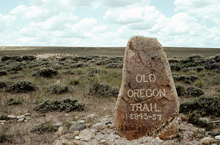
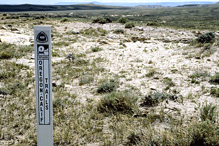
As the Oregon Trail celebrates its 185th anniversary, you, too, can
recapture that spirit of adventure along what remains of the Trail today
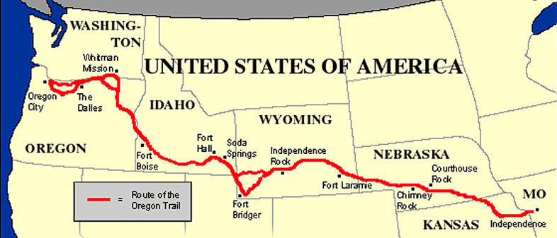
through the six states--Missouri, Kansas, Nebraska, Wyoming, Idaho, and
Oregon—that the Trail passed through. All along the Trail, historic
sites and markers preserve the heritage of the greatest peacetime
migration in human history.
While it’s impractical due to time constraints for many to travel the
entire route of the trail today, it is possible to travel along a
particular section and still get a good view into the overall
experience. Most of the exhibits reflect the hardship, courage, and
endurance of the emigrants.
 You might begin at the beginning—Independence, Missouri. Here you'll
find the new National Frontier Trails Center, built on the site of the
spring where pioneers used to fill their water barrels as they headed
out of town. This complex is the only museum in the country dedicated to
the history of the three major westward routes--the Santa Fe,
California, and Oregon Trails. You might begin at the beginning—Independence, Missouri. Here you'll
find the new National Frontier Trails Center, built on the site of the
spring where pioneers used to fill their water barrels as they headed
out of town. This complex is the only museum in the country dedicated to
the history of the three major westward routes--the Santa Fe,
California, and Oregon Trails.
Interpretive displays combined with actual emigrant diary entries show
you what life was really like on the trail. Period artifacts include
many items discarded from wagon trains and found along the trails. There
is also a 17-minute film on western migration.
As the Oregon Trail left Missouri, it immediately entered what’s now
Kansas, following a common route with the Santa Fe Trail for a few miles
until it reached present-day Gardner. From here it continued in the
direction of modern Topeka, then headed north into Nebraska.
From the Overland Park area just outside Kansas City, through the
communities of Lawrence, Topeka, and Manhattan, you'll find various
markers and actual wagon ruts left by the pioneers.
The Trail enters Nebraska in the southeast
corner, following the Little Blue River, the Platte River, and finally
the North Platte River in a gradual northwesterly route into Wyoming.
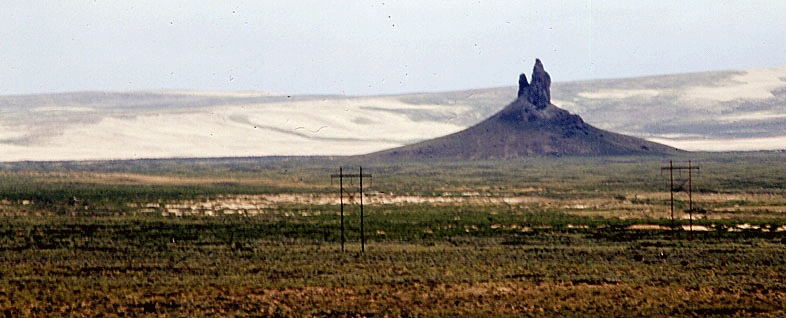
Chimney Rock, the most famous natural landmark
on the trail, is found in western Nebraska, followed shortly by Scotts
Bluff, another natural signpost.
 As the trail enters the state, it passes by Rock Creek Station, now a
state historical park. This way-station served pioneers on the trail, as
well as the Pony Express. You may just see a Pony Express rider charge
in at break-neck speed. A visitors center and ranch buildings offer an
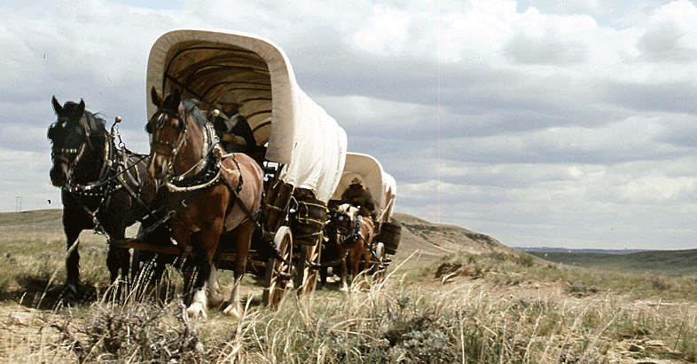
interpretive exhibit. While you're there, take a ride in a covered wagon
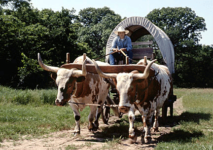
pulled by a team of oxen. Wagon ruts are clearly visible here. As the trail enters the state, it passes by Rock Creek Station, now a
state historical park. This way-station served pioneers on the trail, as
well as the Pony Express. You may just see a Pony Express rider charge
in at break-neck speed. A visitors center and ranch buildings offer an
interpretive exhibit. While you're there, take a ride in a covered wagon
pulled by a team of oxen. Wagon ruts are clearly visible here.
As the emigrants followed the Platte River across Nebraska, they came to
Fort Kearny, another state historical park. Built in 1848 to help
protect travelers on the trail, the fort now features reconstructed
walls—built in later years—parade grounds, a blacksmith shop, and relics
from the trail era. Tall cottonwood trees, planted shortly after the
fort was established, grace the grounds. It was here that emigrants
received their first news from back home.
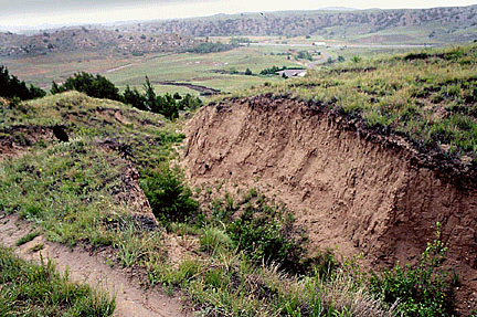 One of the most fascinating exhibits is at Ash Hollow, near Lewellen,
Nebraska, then an oasis in the otherwise treeless prairie. Coming down
into it is Windlass Hill, a descent so hair-raising that--wrote one
diarist--nobody in his company spoke a word for two miles. The old ruts,
eroded by rains, have become a steep scar down the hillside. You can
stand in them and try to imagine wagons coming down that slope wheels
locked and every able-bodied person pulling back on the ropes. Emigrants
reached Ash Hollow 40 days after leaving Independence. More than
two-thirds of the trip--including the roughest part--remained. One of the most fascinating exhibits is at Ash Hollow, near Lewellen,
Nebraska, then an oasis in the otherwise treeless prairie. Coming down
into it is Windlass Hill, a descent so hair-raising that--wrote one
diarist--nobody in his company spoke a word for two miles. The old ruts,
eroded by rains, have become a steep scar down the hillside. You can
stand in them and try to imagine wagons coming down that slope wheels
locked and every able-bodied person pulling back on the ropes. Emigrants
reached Ash Hollow 40 days after leaving Independence. More than
two-thirds of the trip--including the roughest part--remained.
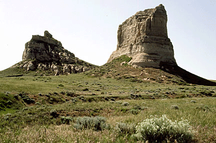
In western Nebraska, the emigrants came upon several natural landmarks
that moved them too awe and bad poetry, as well sharpened their sense of
adventure. Chimney rock, now a national historic site, was the best
known. Courthouse and Jail Rocks, nearby, were two others that let them
know they were on the right track. If you have the time, sign up for the
Oregon Trail Wagon Train treks out of Bayard, Nebraska. They offer a
variety of rides, treks and chuck wagon cookouts. Contact.
 Nearing the border of present-day Wyoming, the emigrants passed Scotts
Bluff, now a national monument, on their way through Mitchell or
Robidoux Passes. This mass of clay and sandstone 4,649 feet above sea
level can be climbed by a one-and-a-half-mile trail on its west side.
Most visitors choose to drive their cars along a road that vanished into
three tunnels as it winds and climbs the steep terrain. The eroded wagon
ruts are especially prominent at the base. A museum features the
paintings of Henry Jackson, Nearing the border of present-day Wyoming, the emigrants passed Scotts
Bluff, now a national monument, on their way through Mitchell or
Robidoux Passes. This mass of clay and sandstone 4,649 feet above sea
level can be climbed by a one-and-a-half-mile trail on its west side.
Most visitors choose to drive their cars along a road that vanished into
three tunnels as it winds and climbs the steep terrain. The eroded wagon
ruts are especially prominent at the base. A museum features the
paintings of Henry Jackson,
noted pioneer artist.
As the emigrants left Scotts Bluff and entered what is now Wyoming, they
were within a few days travel of Fort Laramie, the most prominent
way-station along the trail. Begun in 1834 by fur trappers, Fort Laramie
became a major military post for the entire Oregon Trail. Today, Fort
Laramie National Historic site offers 22 original structures, however,
the emphasis is more on the time period of the late 1880s, well past the
trail's peak period.
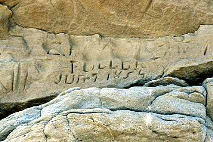 Not far from Fort Laramie, and just south of present-day Guernsey, the
emigrants stopped to camp at a place that became known as Register
Cliff, one of three places in Wyoming where they recorded their passing
and one of 21 trail sites in the area. A mass of grafitti—names,
dates, and places of origin--now covers this 150-foot-high sandstone
cliff. Tell-tale swales remain, close by the cliff and heading westward. Not far from Fort Laramie, and just south of present-day Guernsey, the
emigrants stopped to camp at a place that became known as Register
Cliff, one of three places in Wyoming where they recorded their passing
and one of 21 trail sites in the area. A mass of grafitti—names,
dates, and places of origin--now covers this 150-foot-high sandstone
cliff. Tell-tale swales remain, close by the cliff and heading westward.
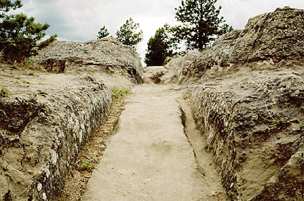
Nearby is Oregon Trail Ruts National Historic Landmark, where the
pioneers had to negotiate an outcropping of sandstone. Here, you can
stand in waste-deep ruts cut by the thousands of iron wagon tires into
the stone. The feeling of the trail is so real here that you can almost
imagine a bull-whacker walking alongside his wagon, cracking his whip
and yelling at his team. The wagon's white cover ruffles in the wind,
its sides creaking with the uphill strain.
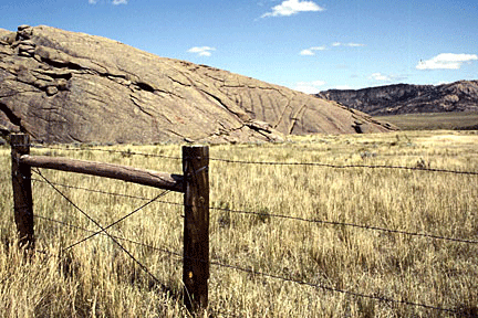
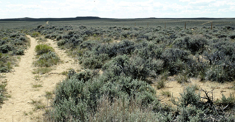
 Many miles of pristine ruts remain on both
private and federal land. The Bureau of Land Management in Wyoming makes
finding the trail easy. Just follow the BLM markers, and read
information provided at the interpretive centers. Little development has
occurred at many trail sites in Wyoming, so
the land is much the same as it was 150 years ago. Many miles of pristine ruts remain on both
private and federal land. The Bureau of Land Management in Wyoming makes
finding the trail easy. Just follow the BLM markers, and read
information provided at the interpretive centers. Little development has
occurred at many trail sites in Wyoming, so
the land is much the same as it was 150 years ago.
Heading toward South Pass, the site of the Continental Divide in south-central
Wyoming, the emigrants stopped at Independence Rock, a 1,900-foot-long
700-foot-wide red felsspar
and mica outcropping named on July 4, 1830, by a group of mountainmen.
Once again, many carved messages all over the 128-foot-high rock for
loved ones following them on the trail. Emigrants raced to reach
 it by
the Fourth of July. For a day or two that camp was loud with gunfire,
boisterous drinking, and patriotic oratory. Today, the rock sits quietly
on the semi-arid plain. it by
the Fourth of July. For a day or two that camp was loud with gunfire,
boisterous drinking, and patriotic oratory. Today, the rock sits quietly
on the semi-arid plain.
If Independence Rock is quiet, South Pass is almost moonlike in its
emptiness. Once described as "a gateway more thronging than Gibraltar,"
the pass is once again a wide, sage-brush covered plain sloping gently
toward the Continental Divide. Instead of columns of wagons, only an
occasional pronghorn antelope disturbs the stillness.
South Pass offered the pioneers the only opportunity to cross the Rocky
Mountains on an easy grade. It was the gateway to the Oregon Country, as
it was called. Today, as back then, it's a broad sage-covered meadow
reached by a dirt road. It certainly doesn't look like one of the most
important parts of the Oregon Trail.
 Beyond South Pass, the rope of pioneers began to fray again. Some chose
the long, dry march heading straight for the Green River. Others went
southwest to Fort Bridger. Fort Bridger,
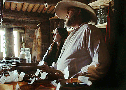
established in 1843 by mountain man Jim Bridger as a fur trading post,
soon became an important supply station on the trail. Today, it offers
probably the best living history program of any site along the trail.
The original trading post--a few crude log buildings surrounded by
picket walls smothered in mud and baked in the sun--has been restored
and now operates as a unique gift shop selling reproductions of items
similar to those sold when the emigrants shopped there. Beyond South Pass, the rope of pioneers began to fray again. Some chose
the long, dry march heading straight for the Green River. Others went
southwest to Fort Bridger. Fort Bridger,
established in 1843 by mountain man Jim Bridger as a fur trading post,
soon became an important supply station on the trail. Today, it offers
probably the best living history program of any site along the trail.
The original trading post--a few crude log buildings surrounded by
picket walls smothered in mud and baked in the sun--has been restored
and now operates as a unique gift shop selling reproductions of items
similar to those sold when the emigrants shopped there.
Soon after entering Idaho, emigrants had to face what is still called
simply, "The Big Hill." You can see deep ruts from Highway 30 near
Montpelier. Every July wagons climb the hill again for the Oregon Trail
Rendezvous Pageant.
After descending "The Big Hill," emigrants stopped for a treat at Soda
Springs in the extreme southeast corner of the state. Here, they enjoyed
carbonated spring water. One spring reportedly tasted like beer, another
like soda.
All the Oregon traffic, and the rest headed for California, went on down
to Fort Hall, another important supply post operated by the Hudson Bay
Company on the Snake River. Only a small monument marks the spot, but a
replica stands in Pocatello's Upper Ross Park. You can wander through
the log house museum from April through September; each July, local
craftsmen demonstrate pioneer crafts.
Beyond the mouth of the Raft River, the Oregon Trail is strictly the
Oregon Trail. One of the most dramatic moments for emigrants came at
Glenns Ferry for those who chose to cross the Snake River at Three
Island Crossing. Today, at Three Island Crossing State Park, you can
view interpretive exhibits and walk down to the riverbank to see the
ruts left by the wagons. A commemorative re-enactment is held annually
in August.
The trail entered Oregon as the emigrants got their last glimpse of the
Snake River at Farewell Bend.
When the emigrants reached Flagstaff Hill near present-day Baker City,
Oregon, they were rewarded with their first view of a lush valley that
offered the true promise of Oregon. The National Historic Oregon Trail
Interpretive Center at Flagstaff Hill, another excellent interpretive
centers along the trail, recently opened outside Baker City. This
complex features an interpretive center, an outdoor living history area
with an Indian village, an emigrant park, a performance amphitheater,
and a festive marketplace.
Finally, the pioneers had reached their goal—the Oregon Territory. Here,
they could begin their lives again.
< Back to
Travel Articles
|